This year I have been invited to a roundtable discussion on this topic at the Arts Valley event in Kapolcs. In this post below I summarise my thoughts on the subject.
There are several ways to approach the subject, so let us start from the point of view of the possible bridge sites mentioned by various experts and politicians. Three bridge names are frequently mentioned: the Albertfalva Bridge, the Galvani Bridge and the Aquincum Bridge. Almost all of these bridges have decades of history and have been the subject of numerous conceptual designs, but the occasional flare-ups are followed by long pauses before they are consigned to oblivion.
 |
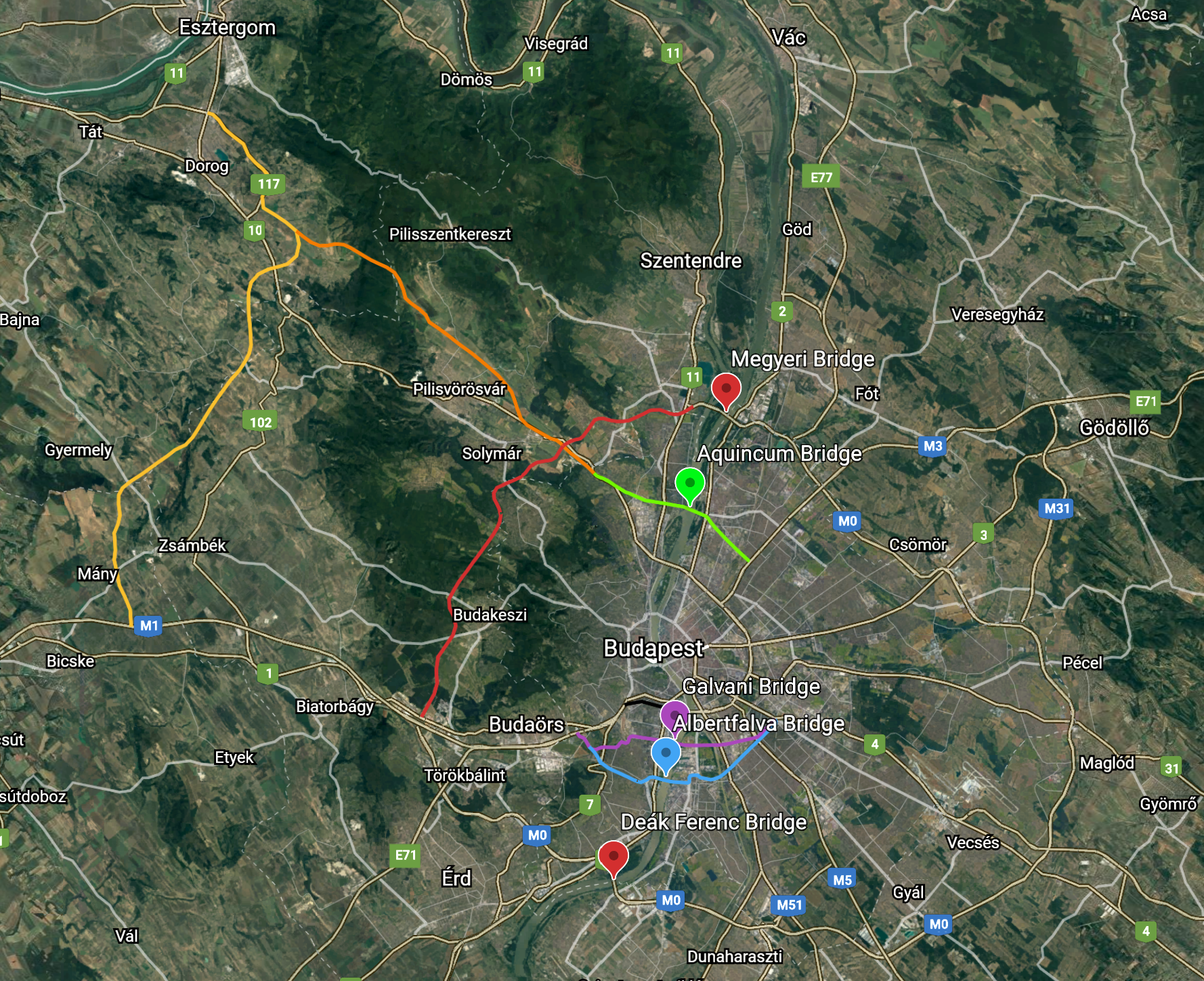
| The Aquincum Bridge (green line), the Galvani Bridge (purple line) and
the Albertfalva Bridge (blue line) with their road networks. |
Anyone with a little knowledge of transportation development will know that bridges are spectacular features of the road network, but they are not a solution in themselves. Budapest's transportation problems are not new, but in many cases new ones are added to the pool. Unfortunately, like so many things in life, the issue of transportation is pervaded by politics. In almost every case, transportation policy that would be in the city's best interests is sacrificed for short-term electoral gain, and it gets worse and worse. Many such cases have happened before. Referring back to the last post, I might mention the choice of the location of the Chain Bridge. The crossing between Pest and Buda was on the axis of the current Vigadó Square - Szarvas Square, which for hundreds of years functioned as a ferry, a boat bridge and a reaction ferry.
 |
| Location of the ancient boatbridge in the present cityscape (white line). |
Then the Chain Bridge was built in a place that had no road connection at all. On the Buda side, in the absence of the tunnel, those crossing the bridge found themselves in front of the Castle Hill, from where they could continue their way to the north or the south. In Pest, there is still no meaningful road connection today. The location of the Chain Bridge adversely affected the location of the later Erzsébet Bridge, which also lacked a proper road connection. In Buda, the crossing is located in front of the Gellért Hill, from where again it is only possible to continue to the north or the south, while on the Pest side a new avenue (today's Kossuth Lajos Street) was built, breaking up the historic city centre. One of the biggest mistakes of the past decades is the road connection on the Buda side of the Lágymányosi Bridge (now Rákóczi Bridge), built in the mid-1990s. The bridge basically had good road network connections on both sides, but due to protests from local residents, the link to the M1/M7 was never built on Hamzsabégi Road. The abandonment of a decades-old road was a mistake. Standing up for the protesters may have won political votes in the short term, but in the longer term it made transport impossible for the whole city. The creation and extension of the Egér Road, Andor Street, Szerémi Road route to replace the failed road link will result in a significantly greater violation of interests.
 |
| The Rákóczi Bridge and the Hamzsabégi Road (black line) on Buda side.
The Galvani Bridge and its associated road network (purple line). The
Albertfalva Bridge and the connected roads (blue line). |
Of course, mistakes were not only made in past decades or centuries; they also abound today. The M0 ring road also plays an important role in Budapest's transportation system. Or, rather, it would, if it could really function as a ring road. According to the latest government plans, the western sector of the M0 would not be built at all, but instead a new road (M100) would be built from Bicske to Esztergom, and from there the M10 would be used to return to the city. In terms of east-west direction, this would be an even bigger detour than the unnecessary extension of the eastern sector, which was also a mistake. In fact it is not an alternative at any level. Besides football and epidemics, it is perhaps transportation policy that everyone believes themselves to be an expert of, and they are capable of saying horrible things. Many experts and politicians have expressed their often very different opinions on the subject, but of course no consensus has emerged.
 |
| The latest government plan M100 from Bicske to Esztergom (yellow line)
and M10 (orange line) motorways. The western and the north sectors of M0
motorway (red line). |
I will try to summarise briefly the principles on which I believe the M0 ring road should be based and the traffic needs of the three bridges' associated road network. First of all, it is important to recognise whether we are dealing with local or transit traffic when designing a road network system. There are no closed ring roads in Budapest, but there are many radial roads. The ring roads (Grand Boulevard, Hungária Boulevard) run between arterial roads 1 and 11 on the flat Pest side. From the outer Buda regions, access to the city centre is via the Hűvösvölgyi Road and Budakeszi Road, which merge at the Szilágyi Erzsébet Alley. Congestion has been persistent here for years and, in the absence of an alternative route, the situation will not change in the future. The only real change could come from the construction of the western and northern sectors of the M0 motorway, which could function as an external ring road. Most local traffic would then be diverted away from the city centre towards the Megyeri bridge and the M1/M7 motorway. The freight and transit traffic that pass through the capital city would have to use the southern and eastern sectors of the M0 obligatorily.
Looking at the bridges and their associated road network, the Deák Ferenc Bridge on the southern M0 is a transit bridge. The Megyeri bridge would serve the transit traffic of the future western sector. Commuters arriving from the M1/M7 will continue to use the Erzsébet Bridge and the Petőfi Bridge. If the Hamzsabégi Road link were completed, the Rákóczi Bridge would be accessible by a shorter route than at present. Commuter traffic could be reduced by the construction of P+R parking, but without this, no significant change is to be expected. Traffic calming on these three bridges could be achieved by allowing residents to use alternative routes within the city. The Árpád Bridge, the Margit Brigde, the Szabadság Bridge and the Chain Bridge already carry local traffic, although the latter is so small that it could be converted into a pedestrian bridge (see previous post). The previously mentioned Albertfalva Bridge, Galvani Bridge and Aquincum Bridge would play an important role in serving local traffic. Let us see these bridges one by one.
The Albertfalva Bridge could perfectly serve the local traffic needs. The need has been expressed for many decades, but there is still no bridge on this stretch of the Danube. The bridge linking Budafok with Csepel city centre on the Buda side has no ring road network and can only be approached from north-south. From time to time it is suggested that a new ring road could be built by constructing a tunnel to the M1/M7, but frankly, this will never happen and would be completely pointless. To serve local traffic, the maximum that could be justified would be 2x2 road lanes and 2x1 tram lines. The 2x2 road lanes in my point of view also means that initially 2x1 lanes would be built and separated bike lanes and wide sidewalks. Bridges are planned for 100 years, so it should not be impossible for our successors to develop other solutions in the future. The Csepel part of the bridge road network is easy to develop, while on the Pest side the Határ Road/Kiserdő problem is presented. A new ring road on the south-western side is as utopian as the aforementioned tunnel on the Buda side. If the number of people potentially using the bridge is taken as a basis, this bridge should probably be built first.
 |
| Galvani Bridge and its associated road network from Buda side (purple
line). Albertfalva Bridge and the connected road network (blue line). |
The Galvani Road Bridge (New Danube Bridge) has a long history. In 1992, there was a national design competition with 15 participants, but the Lágymányosi Bridge (now the Rákóczi Bridge) was built instead. In 2017, another international design competition with 17 participants was launched, which was won by the UN Studio / Buro Happold duo (see previous post). The connected road network of the bridge serves local purposes, but has a direct connection to the M1/M7 motorways via the Egér Road. There is no road network on the Pest side and, as mentioned for the Albertfalva Bridge, the Határ Road/Kiserdő endpoint has not yet been reached. Due to the failure to connect the M1/M7 to the ring road on the Buda side of the Rákóczi Bridge, those traveling on Szerémi Road look for an exit to Egér Road/Andor Street. Egér Road/Andor Street also serve the Galvani Bridge, making this part of Kelenföld unlivable. We have to admit that a 2x2 lane Andor Street would never be approved today. Compared to the traffic on the Albertfalva Bridge, this would serve far fewer local residents and would serve more the commuters. This bridge location has always been intended to serve the giga-investments in crescent of the Csepel island. In recent years, we have witnessed a constant change of function, from Olympic site to Student City to Fudan University. It can be seen that without function, this route cannot survive. If there is any related investment, then building 2x2 road lanes and 2x1 tram lines would be justified, otherwise 2x2 road lanes would be more than enough.
 |
| Galvani Bridge and its associated road network from Pest side
(purple line). Albertfalva Bridge and the connected road network (blue
line). |
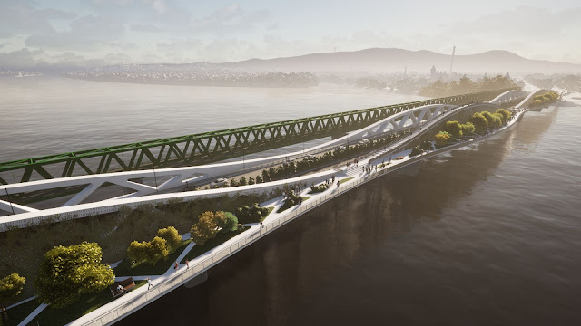
If we recognise its potential, the Aquincum Bridge could be one of the most promising bridges. This bridge could also be a prime example of local traffic diversion. The bridge would be built on the north side of the Északi Összekötő Railway Bridge, which currently carries pedestrian and cyclist traffic in addition to rail traffic. There is no road connection between Újpest and Romaifürdő/Csillaghegy, so there is a considerable detour to cross to the other side of the Danube. On the Buda side, a road link to the bridge has already been planned to arterial road 10, but there is no sign of the ring road on the Pest side, so Váci Road would most likely be the temporary endpoint. Like the Galvani Bridge, this bridge has a long history, having been the subject of a conceptual design in 2000 and also of my thesis (2001). The design of a new bridge is constrained by the 700 m long, monotonous, repetitive truss structure of the adjacent railway bridge and its seven identical spans of almost 100 m.
 |
| Aquincum Bridge and its road network (green line). |
The new bridge has to respond to all this, while at the same time meeting traffic demands to the maximum. It is typical of pedestrian bridges that they have additional functions, but it would be rather fortunate if a road bridge could also meet these needs. Looking north from the bridge, you can see the 600 m wide Danube, bordered on either side by forest and trees, with the peaks of the Börzsöny and Pilis Mountains in the background. The bridge is not just a crossing point, but also a unique viewpoint or urban space from which unusual perspectives can be enjoyed. In the middle of the bridge we are 300 m away from the riverbank, 10-15 m above the water surface.
 |
| Looking north from the Aquincum Bridge. |
You can almost feel as if you were in an undisturbed natural environment if you can ignore the occasional train noise. There have been several attempts to create park-like bridges around the world, but none have been built so far (Garden Bridge, London - Heatherwick Studio; Dawn Bridge, Shanghai - MVRDV; Babylon Bridge, Paris - Rescubika; etc.)
The main problem is the considerable deadweight load that bridges designed to be slender cannot carry. The situation can be improved by decreasing the span, but this is unfavorable to shipping. In the present case, the 93 m span is not a large distance, which nowadays can be easily spanned.
I will give a detailed explanation of my proposed solution in a forthcoming post, so for now let me just give a brief summary. The bridge is a straight, 10-span, truss girder bridge with a length of almost 700 m. One to one new bridge pier will be placed in the middle of the 93 m long outermost spans. The design of the bridge is defined by the unique truss girder, which is undulating in the horizontal and the vertical plane. This structure would be the first road bridge with a wide area for pedestrians and cyclists. The width of the north side curved terraces varies between 7-14 m. The terraces will be supported by horizontal trusses. The triangular-shaped fill-elements can be varied as desired with different functions. Around 50 m² of surface area could be used to create any number of features for pedestrians (e.g. sunbathing area, grassed area, plant groups, benches, swings, mini garden, pool, fountain, waterfall, outdoor gym, etc.). Of course, the triangle-shaped holes can be covered with steel plates or glass panels, or can be without any covering. The triangle-shaped fill-elements can be lifted in and out using a mobile crane, so the appearance of the bridge can be changed from time to time, rearranged seasonally or themed for different events. The triangles of the almost 10 m high vertical plane trusses are fitted with noise barriers to reduce noise from road traffic. The north side of the truss is planted with creeping ivy, as in Széllkapu Park, so that the north side of the bridge would have a basically green, lush, park-like appearance. The distance between the two trusses is 18 m, which could be used for a 2x2 lane layout in the future. However, the initial phase would accommodate 2x1 traffic lanes and separated cycling lanes. The south side could be retrofitted with a 3.6 m wide cycling lane at the far end. A stairway would lead up to the top of the northern middle truss, offering a panoramic view of the city centre looking south.
 |
| Aquincum Bridge with 2x1 traffic lanes and separated cycling lanes. |
 |
| Aquincum Bridge with 2x2 traffic lanes and separated cycling lanes on the south side. |
|
| Aquincum Bridge with 2x1 traffic lanes and separated cycling lanes. |
 |
| Aquincum Bridge with 2x2 traffic lanes and separated cycling lanes on the south side. |
 |
| Aquincum Bridge with 2x1 traffic lanes and separated cycling lanes. |
 |
| Aquincum Bridge with 2x2 traffic lanes and separated cycling lanes on the south side. |
 |
| Aquincum Bridge with 2x1 traffic lanes and separated cycling lanes, from birds eye view. |
 |
| Aquincum Bridge with 2x1 traffic lanes and separated cycling lanes, top view. |
Finally, it is important to note that bridges are also worth building without an extensive ring road network (e.g. Monostor Bridge, Pentele Bridge, Paks Bridge, Szekszárd Bridge, Mohács Bridge). It is also important to bear in mind the temporality, i.e. until the link road network is built, the number of lanes on the deck should be limited to match the local traffic. Widening the bridge afterwards is not an economical solution, therefore the full width of the bridge deck should be built (taking into consideration the future improvements), but it could be equipped to meet current needs (e.g. 2x1 lane first, with enough room to accommodate 2x2 lanes for later use).
Unfortunately, no pedestrian bridges have yet been built in Budapest, although bridges with additional functions are needed, for example on Margit Island, Hajógyári Island and many places on the Danube branch of Ráckeve. The answer to the question posed in the title is that the city needs at least three road bridges and at least ten pedestrian bridges, all serving local traffic.
 |
| The location of the suggested pedestrian bridges. |
Bridges are special objects, both physically and symbolically. Everyone has an opinion about bridges, but the public has been socialised on bridges that are rather plain constructions and, from an aesthetic point of view, leave much to be desired. The number of people who use bridges by far exceeds the number of those who go to museums, libraries, theatres, cinemas, concerts, etc., so it should be recognised that it does matter from the aspect of visual culture how a bridge looks and how it fits into its environment. Bridges are basically monofunctional, but in the case of urban bridges, the idea of a multifunctional bridge is not a bad one. It is always a good thing to have a design competition, to choose the best bridge. Of course, this requires a professional jury that can judge the qualities of the bridge. If politicians or other heads of the state authorities can decide which bridge is the best, based on their own personal taste, there will be no change. This is simply a misunderstanding of roles. If politics were to move out of the areas originally occupied by the experts, better engineering solutions would be found. Let politics focus solely on speeding up bureaucratic processes.


Megjegyzések
Megjegyzés küldése